


The Greatest Saunter
Part I: Inquiring Minds

In between 28th and 29th St. — not even a tenth of the way into the Great Saunter — my umbrella flipped inside out as the rain hammered down and the wind ripped, and it hit me with the certainty and fury of a freight train that I had no chance of completing this delightfully stupid 32-mile hike around the island of Manhattan in a rainstorm.
I had been preparing for and generally looking forward to this day for five months. Now, that had all been washed away in a couple of hours.
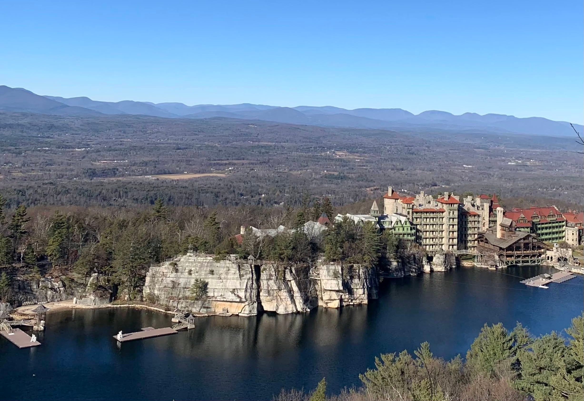
It was pure serendipity that I’d even arrived at this moment, at this attempt to circumnavigate Manhattan by foot. Back in December, I’d ducked into Inquiring Minds Bookstore in New Paltz, New York, the Hudson Valley town that was serving as my base camp for hikes to the nearby sky lakes of Minnewaska State Park and to the Sky Top Tower which crowns Mohonk Mountain, overlooking Mohonk Lake and the Mohonk Mountain House, a stunning “Victorian castle resort,” as the website puts it, originally built in 1869.
There it was sitting on the shelf, prominently placed, in the charming little shop where books were stacked — nearly to the ceiling — in all directions.
Walking The Hudson: From the Battery to Bear Mountain
It was on my second trip into Inquiring Minds when I finally decided to pluck it off the shelf. $12.98 well spent.
I had been doing a lot of walking — well, walking, hiking, running, and, generally exploring in the past six months — I had a personal history with New York City and an immediate affinity for the Hudson Valley. So, it only made sense.
Walking The Hudson — which guides its reader along a trail from the southern tip of Manhattan to Bear Mountain, the popular and picturesque Hudson Valley hiking spot some 45 minutes south of where I currently was in New Paltz — was my introduction to Cy Adler. It was my introduction to Shorewalkers, his non-profit environmental organization, and the group’s crown jewel event, the Great Saunter.
Trained as a mathematician, physicist and oceanographer, Adler worked as a professor, author and organizer. Back in 1952, when Adler was a graduate student at NYU, living in an apartment for $15.50 a month, he joined the crew of a Norwegian ship that was supposed to sail around the world. They only made it as far as Manila. On the way back, Adler got in a fight with another sailor who bit him in the chest, right near his neck. He almost died.
Above all, Adler was a conservationist.
The long-time Upper West resident, who died of a stroke in 2018, founded Shorewalkers in 1982. The organization “is dedicated to promoting and preserving New York City’s waterfront, as well as raising awareness of its shorelines by leading invigorating hikes throughout the metropolitan area.”
The first hike took place on Sunday, December 12, 1982.
“Explore the changing Hudson River Coast, Battery Park, the Westway Route, active piers, through Penn-Central railroad yards and into Riverside Park,” the Shorewalkers’ announcement read, as Adler recalled in a 2015 blog post — a blog post I would have never uncovered if not for Pam Cress, the current president, who was kind enough to send it to me.
“Lunch stop in Harlem. Wilderness above the George Washington Bridge, wind up in an Irish pub in Inwood.”
Beer cost 15 cents a glass and “the paths were unsafe and often illegal to access.” Throughout the 1980s, participants had to climb through a hole cut into a fence by an NYC Parks official.
The date of the first official Great Saunter is “up for debate,” as Adler put it in the same post.
After a vote, 1985 was declared the winner. In the years leading up to the inaugural event, less than 30 people walked. By 1987, the number had risen to 100.
I was taking part in the 35th edition of the Great Saunter on May 7, 2022 along with 2,499 others. At least, that was the number of registrants before the rain swept in. For the first time in its history, the Great Saunter had sold out.
It takes a moment to warm up to Adler’s writing style. He packs an absurd, astounding amount of information, history and New York knowledge into each sentence. This is true of Walking The Hudson and his Saunter-specific book:
Walking Manhattan’s Rim: The Great Saunter Adventures And Discoveries On The Shores Of The World’s Richest, Most Varied Island
As I made my way through Walking The Hudson — starting in Battery Park, meandering along the river, zipping past the Little Red Lighthouse and continuing across the towering George Washington Bridge into the Palisades — I couldn’t help but marvel at how any one person could know so much about any one place.
Take those riverside cliffs across from New York City, for instance. The Palisades, incidentally, might no longer exist if not for the the intervention of robber barons like J.P. Morgan and John D. Rockefeller Jr. in the 1890s, who bought up the quarries where the cliffs were being turned to rubble and then shipped across the river for street paving and construction, leading to the creation of the Palisades Interstate Park, as Adler details.
And I couldn’t help but notice how much he despised cars — utterly. Adler despised cars, the pollution they emit, and all the freeways, highways and roads that have been built up to the benefit of the driver and to the detriment of the biped (his term) and the bicyclist.
While Walking the Hudson had led me directly and inevitably to the Great Saunter, it was not, in fact, the first walking book I’d read along this meandering journey which had resulted in me standing along the Hudson on that miserable morning in Manhattan — my hat, jacket, socks and shoes soaked through.
I’d spied the book — Walking to Vermont: From Times Square into the Green Mountains—A Homeward Adventure — almost as soon as I’d stepped into The Joint Free Public Library of Morristown and Morris Township.
I had to check it out. It just made too much sense.
It was June of 2021, 11 months before the Great Saunter. Improbably, I found myself summering in Morristown, the New Jersey suburb some 2,900 miles from my San Francisco apartment, where my girlfriend, Allison, had grown up. With the pandemic allowing her to work from home, or, in this case, her childhood home, I was along for the ride.
I didn’t have a job, per se.
Well, I did — I was in charge of all things digital for a sports radio station back in San Francisco. But, at that moment, I was on an indefinite medical leave of absence after sustaining two concussions in less than a year — the second of which occurred after I tripped over a tree stump while playing frisbee. Yes, I’m not kidding.
After nearly a decade of toiling away in sports media — the exhilarating, yet grueling industry, which, famously, never sleeps — I found myself with a new currency, time.
I became a master of the NJ Transit system, exploring nearly every train stop between Morristown and Penn Station — the parks, swamps, marshes, ponds, lakes, waterfalls and forests of New Jersey, the delis, coffee shops and downtowns, the historic greens and Revolutionary War battlefields. I was forever checking town signs to see when, in the distant past, they were founded.
It was a whole new world on the East Coast. Everything was so old.
There was no such thing as stumbling into a colonial village — or, at least, streets lined with buildings that gave off that appearance — in California. In New Jersey, I saw that in nearly every town, township, borough and village.
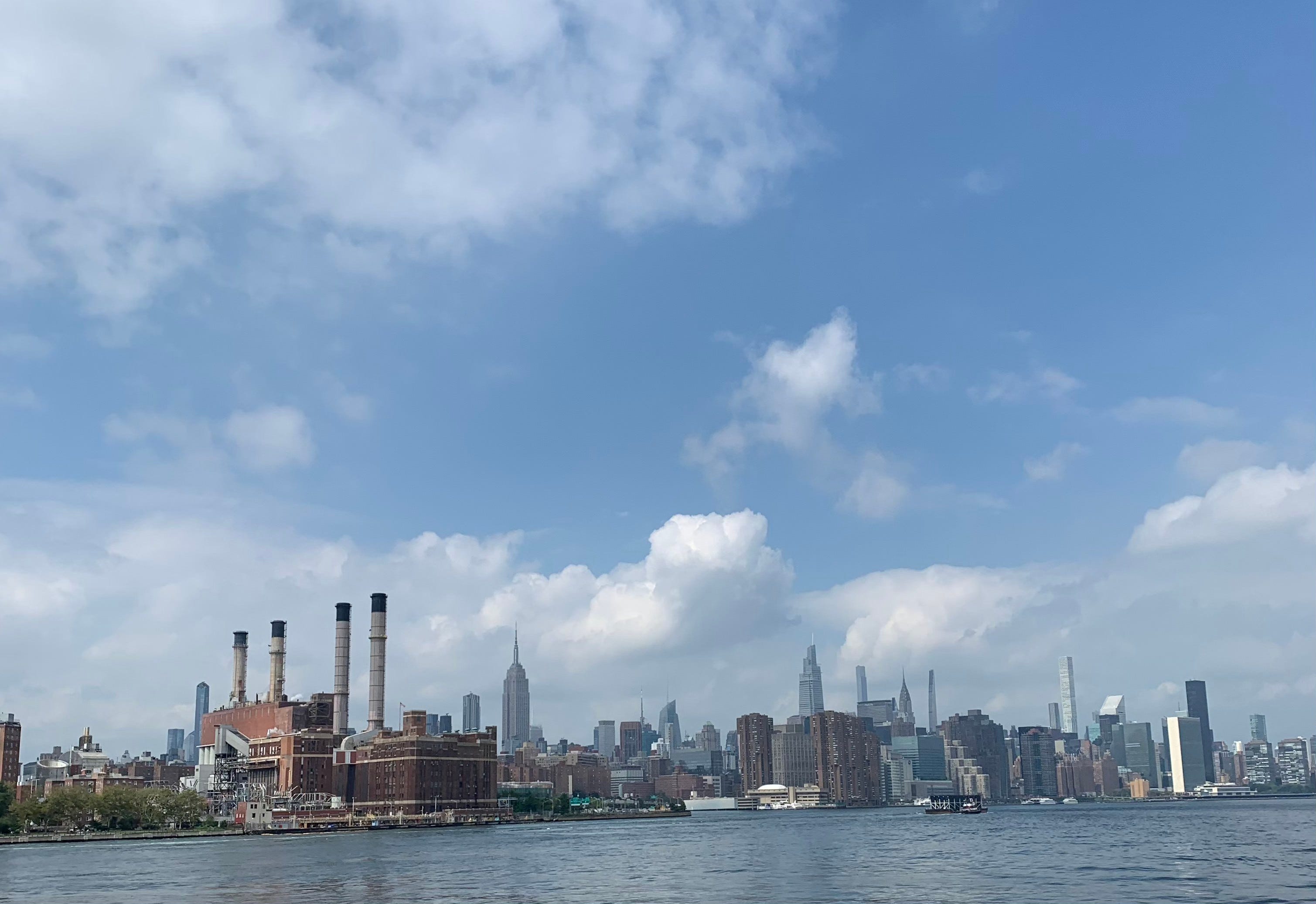
I explored New York City, too — making eight day trips to my erstwhile home where, in a distant past, I’d studied History at NYU. I rambled all around the island, sometimes running, sometimes walking. I discovered NYC Ferry, the best $2.75 you’ll ever spend. I jetted up and down the East River, marveling at all the sights — the old factories along the Brooklyn waterfront, the American Copper Buildings (the dancing towers, connected by a skybridge) and the ConEd power plant, which became an improbable favorite.
And those bridges.
Brooklyn
Manhattan
Williamsburg
Queensboro
The last of which might just have the distinction of being my favorite bridge of all. Officially the Ed Koch Queensboro Bridge, the double-deck cantilever bridge reaches 350 feet into the sky, spanning from the eastern edge of Manhattan into Queens and stretching over Roosevelt Island — a narrow sliver of an island that runs for approximately two miles in the East River from 47th St. up to 86th.
It was one of the many places in New York I explored. Aside from having a ferry terminal on its eastern bank, on the opposite side is the station for the Roosevelt Island Tramway, which I couldn’t believe existed. The tram soars over the East River — reaching a peak of 250 feet — before dropping you off at Tramway Plaza, located at 59th St. and 2nd Ave., right next to the Queensboro Bridge.
It’s remarkable. Right in the middle of New York City is the tram, like some gondola climbing up a pass in the Alps — which is fitting since it was built by a Swiss firm, at a cost of $5 million, in 1976. Since then, 26 million passengers have made the trip.
I rode further up the river, past Randalls Island and under Hell Gate Bridge, a red railroad crossing, which spans a notoriously dangerous stretch of water. Then I continued past North Brother and South Brother Islands, both uninhabited and closed to public access.
A decaying wooden dock and the Riverside Hospital can be seen on North Brother Island. The forest, and, most prominently, the ivy are reclaiming the crumbling brick structure of the hospital — where starting in the mid-1880s patients with a variety of quarantinable diseases were housed and treated. Mary Mallon, more infamously known as Typhoid Mary, spent 23 years marooned on the island before her death in 1938.
The city does occasionally allow researchers and journalists, escorted by NYC Parks staffers, to tour the islands, which now operate as sanctuaries for water birds.
I would absolutely love to kayak across the river or drive up to the ruined dock in a zodiac and trespass onto the island. Or, better yet, explore all around on an officially sanctioned visit.
Up next is Rikers Island, New York’s most well-known jail, which recently had its own disaster with quarantinable diseases when 21% of the inmate population was infected with COVID-19 as of December 2021, per a report from the city’s Correctional Health Services.
I’m further north (and, as I think about it, east) up the river than I’ve ever been. I jump off at Soundview in the Bronx, which was, at the time, the final stop on the route. I quickly catch a southern-bound boat to get me back to my familiar Manhattan.
On another day — a beautiful Monday in early July — Allison, a few of her friends and I took the ferry all the way from Wall Street to Rockaway Beach where rows and rows of giant apartment buildings loom just beyond the sandy shores.
As the skyscrapers of the Financial District receded into the distance, we cruised past Governors Island, and the Statue of Liberty behind that. Then we continued through the Narrows and under the Verrazzano-Narrows Bridge, which connects Brooklyn to Staten Island and rises 693 feet into the air. The bridge takes its named from Giovanni da Verrazzano, the Italian explorer working on behalf of the French, who, almost exactly 500 years ago, in 1524, became the first European to sail into New York Harbor and up what is now the Hudson River.
At this point, we’re headed out into Lower New York Bay, and, eventually, the Atlantic. But, instead, we hook left riding past Coney Island, into Rockaway Inlet and then Jamaica Bay before landing at the Rockaway terminal just a few blocks’ walk from the beach on the Atlantic coast.
I did a poor job of chronicling that summer, writing a smattering of sporadically updated dispatches via the iPhone Notes app that I titled “A ride through New Jersey.”
7/9
Friday
Back to New York. The marshes of New Jersey were thick and green, tributaries snaking through the grass, like wandering serpents, hungry.
The sky was gray but the weather was pleasant. Taking the train into Penn Station. Then the subway up to the Upper East Side to decamp from there.
One of the few items on the calendar that summer was a wedding in the quaint little village of Grafton, Vermont — with a population of 645, as of the 2020 census — tucked into the Green Mountains.
There I was, rambling all over New Jersey and New York. And here was this book, dropped right into my path, the literal guidebook for an Alderesque saunter from New York City to Vermont. Serendipity.
Walking to Vermont details veteran New York Times reporter and editor Christopher S. Wren’s trek from his office in Times Square — on his final day of work — to his house in Fairlee, Vermont where he’s set to retire.
Interspersed with memories from his 28-year career as a foreign correspondent in outposts like Cairo, Beijing, Ottawa and Johannesburg, Wren’s account provided me with a step-by-step guide, a cheat sheet, a roadmap for the hikes I was about to take.
7/14
Wednesday
Driving to Vermont. So many forests as we drive through northern New Jersey, heading towards New York, the Hudson River Valley. The trees are bulging out onto the thoroughfare, threatening to swallow up the road.
Two days later I was standing on the top of Stratton Mountain, which can stake a claim as the birthplace of both the Long Trail — which runs the length of Vermont and is the oldest long-distance trail in the United States — and the Appalachian Trail. Incidentally, those two trails coincide for roughly 100 miles in southern Vermont.
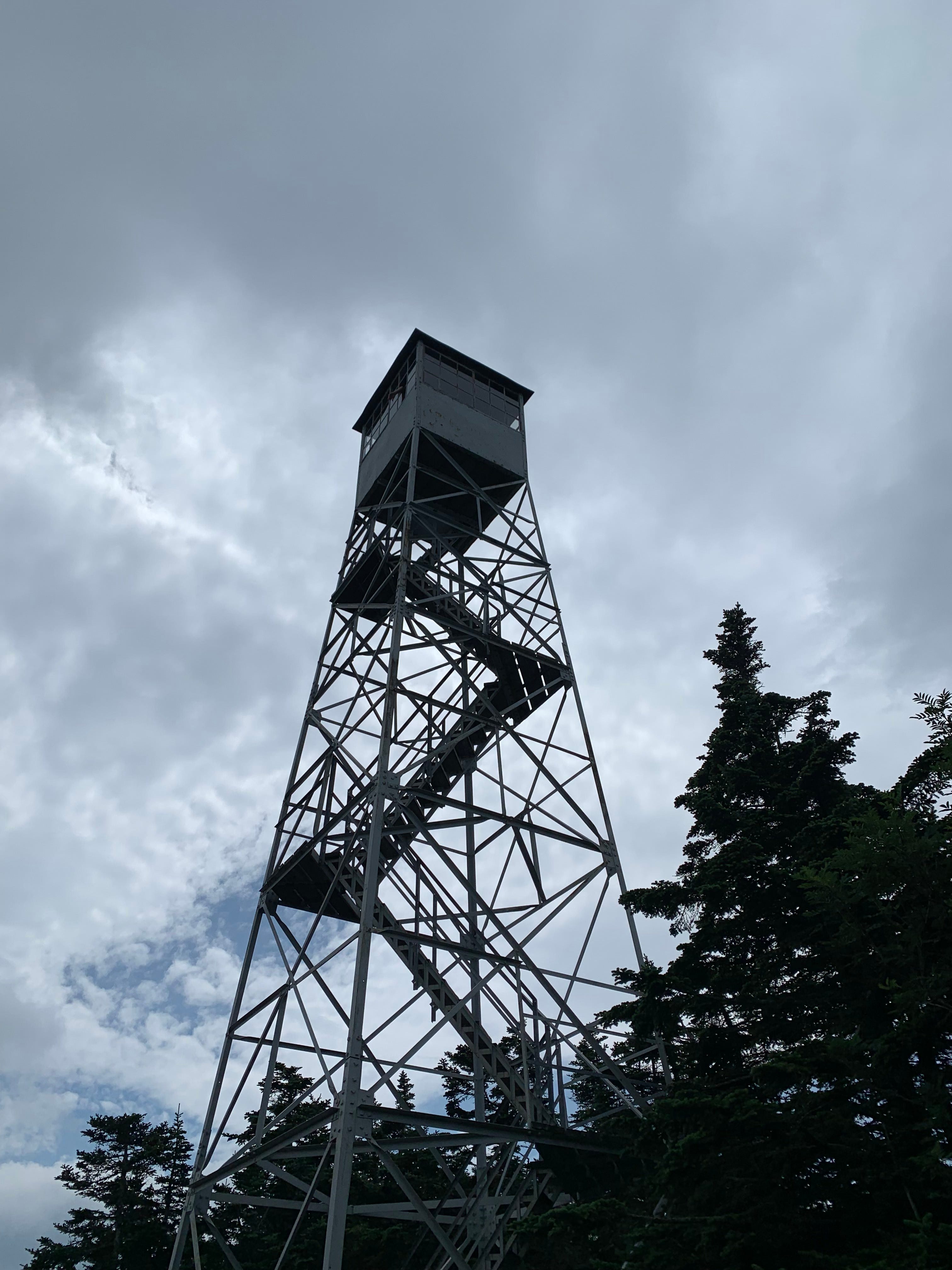
Stratton Mountain was also my favorite hike that I learned about from Wren. In the interest of full disclosure, we didn’t hike to the top of the 3,199-foot mountain, but rather rode the gondola to the summit. Should you find yourself in Stratton — the home of the renowned resort where snowboarding was born — I emphatically recommend taking the gondola up.
At the top of the mountain, we followed the Long Trail/Appalachian Trail through a dense woods along a muddy track to the fire tower. The 70-foot climb through the swirling wind terrified me, and reminded me that for someone who is so often perched in precarious places atop bridges, mountain tops, the edges of cliffs and rickety fire towers, I am, indeed, from time to time afraid of heights. The climb also afforded us incredible 360-degree views.
Back on the summit, I signed my and Allison’s names in the Appalachian Trail log book, even though we’d completed just a few miles.
Wren’s Walking to Vermont and Adler’s Walking The Hudson and Walking Manhattan’s Rim were three of the foundational texts of the nearly year-long saunter that led me to the Great Saunter.
After my medical leave of absence turned into a five-day misadventure in law school and then a full-on sabbatical — in which I maintained a part-time job only to have some semblance of an income — I had a wealth of time to walk, to run, to wander, to explore, to saunter.
I went all over.
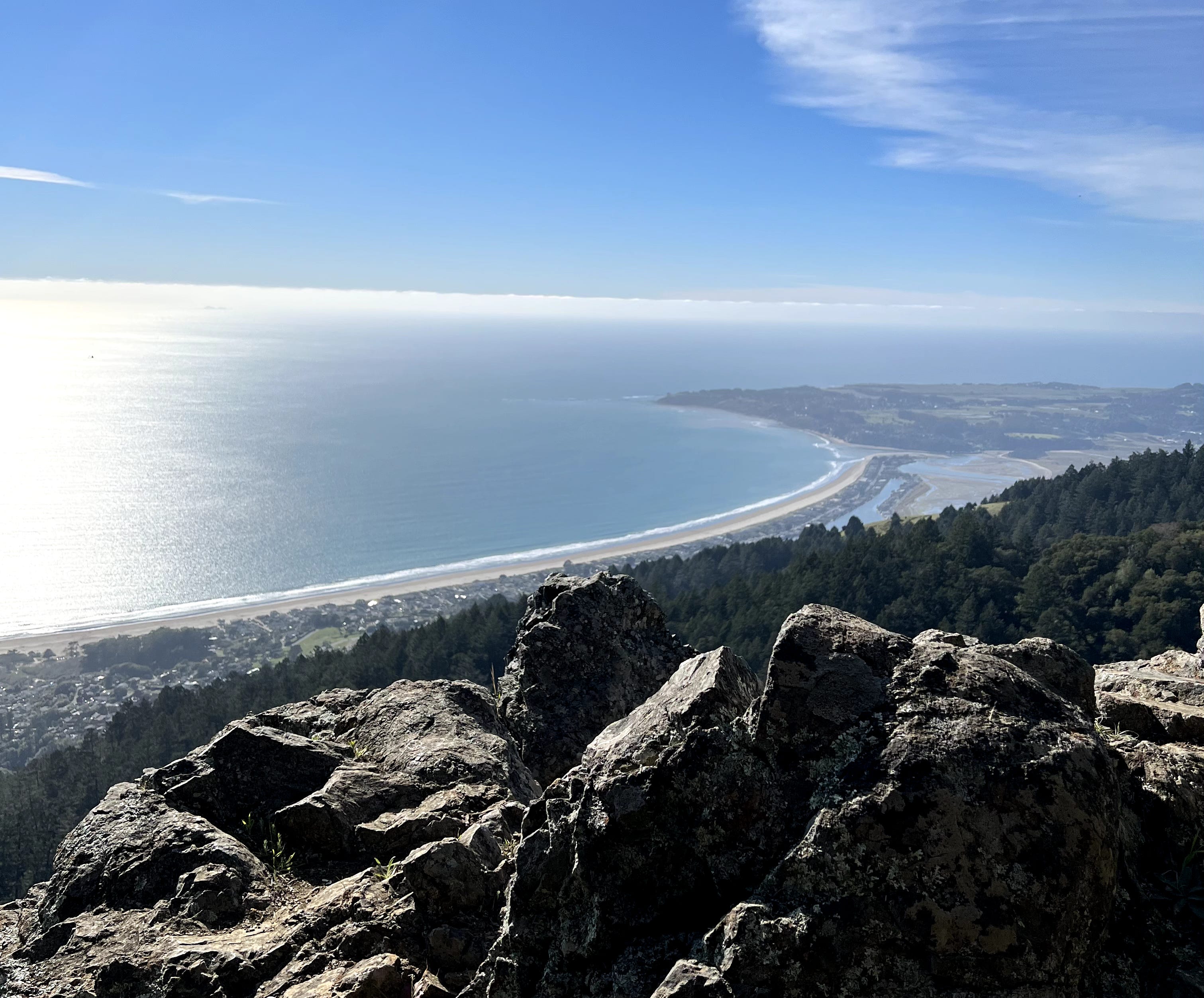
Up Vernal and Nevada Falls in Yosemite. To the Channel Islands off the coast of California by way of a ferry ride past a megapod of dolphins. To Tahoe, twice. On one occasion, through the spring snow up to the site of the former Stateline Fire Lookout, high above Kings Beach, overlooking Crystal Bay and the giant lake, the emerald water hurrying toward the shore, the waves glistening in the evening sun. Along the Bolinas Ridge on the far side of Mt. Tamalpais where hang glider pilots launch themselves off the mountain only to float over Stinson Beach and the Pacific. Along the relentless Dipsea Trail — with its 670ish steps — from Mill Valley to Stinson. A trail so unforgiving that I cracked my ankle so severely it required several months of physical therapy to heal it, mostly. To the roof of Mt. Tam, the 2,579-foot peak in Marin, which is topped with a still-active fire tower of its own, the Gardener Fire Lookout — with its rock walls and barbed wire wrapped around all sides, sitting like some little turret on the summit. Along the shores of Alpine Lake, Bon Tempe Lake and Lake Lagunitas, which I first spied while standing atop Mt. Tam, admiring its one-of-a-kind, 360-degree views of the greater Bay Area. 15 miles, or so, northwest to Bass Lake, Crystal Lake and Pelican Lake, which led me quite by accident to Alamere Falls, a stunning and powerful waterfall that crashes onto the beach before channeling into a stream that spills into the Pacific. To the Marin Headlands, which tower over the Golden Gate Bridge and San Francisco beyond. To the top of Mt. Livermore, the high point of Angel Island, which is accessible only by ferry — unless you are lucky enough to have access to a boat. And to the island’s secret beach on its far side where I went for an impromptu swim and dried off in the afternoon sun. Along the northern shores of San Francisco, my de facto backyard — Fort Mason, Aquatic Park and its crumbling Municipal Pier, Crissy Field. Up into the Presidio. All through the city, as far south as Fort Funston and its soaring dunes — looking hundreds of feet below, dogs bounding along the sand, soaking up the sun as the waves rolled up, lapping, interminably, upon the beach. Up Sweeney Ridge, high above Pacifica with views of water on both sides. The very overlook where, in 1769, Spanish captain Juan Gaspar de Portolá and his expedition party became the first Europeans to lay eyes on the San Francisco Bay. Down into the Santa Cruz Mountains where I lay on my stomach, clinging to the edge of a cliff, in Castle Rock State Park. All through the redwoods of Santa Cruz. And finally back to New York, back to the Hudson Valley, which brings me to my final foundational text.
Bill Bryson’s A Walk in the Woods: Rediscovering America on the Appalachian Trail tied it all together. Rare is the trail guide, like Bryson, who can take you from plodding along a nondescript trail in New Hampshire to laughing out loud in the space of a paragraph, or even a single sentence. His humor is dry, sharp, incisive and forever looming around the next bend in the trail.
When I looked at the calendar, I realized I had some good fortune. The Great Saunter was slated for Saturday, May 7. Exactly one week before that, I was due to be in my brother’s wedding in St. Augustine, a delightful little city on the northeastern coast of Florida. It’s a place bursting with history and which claims to be the oldest city in the United States.
And thus the Greatest Saunter was born.
There was no point in going home. I would just spend the week rambling up from Florida to New York. In the first iteration, I imagined making my way by train. I love trains. But the logistics would be problematic. My flexibility would be low. So, then I planned to drive all along the coast, across the eastern edge of Georgia and South Carolina, along the Outer Banks of North Carolina — a route which would have required me to drive my car onto two ferries in a single day — into Virginia and across the Chesapeake Bay, through Delaware, then onto one more ferry to ford the Delaware Bay up to Cape May, New Jersey, and finally up to Philadelphia where I’d dump my car and board a train toward New York. Maybe I’d stop in New Jersey and ride a ferry, triumphantly, across the Hudson.
In one early version, I even laid out a plan to boat over to Tangier Island, which is sinking into Chesapeake Bay and will be gone entirely, in a matter of decades, thanks to storms eroding its shores and sea levels rising.
I even created a Google Map called “The Great Saunter, Extended.” When you’re already set for a 32-mile jaunt, what’s another 1,000ish-mile drive tacked on?
Aspirational. Ambitious. Perhaps, I realized, a bit too much.
In the days before I was set to take off, as I was buzzing through Byrson’s book, it occurred to me that I was not locked into my planned-on route. The Eastern Seaboard was my canvas to paint upon as I saw fit.
It’s possible I was inspired, if only indirectly, by Bryson who very early on in his journey realized there was no chance he was going to walk the entirety of the Appalachian Trail.
Instead, he made liberal use of his car skipping over large swaths of the trail he deemed uninteresting or dull. He refreshed himself by returning to his family in New Hampshire and then using his own house as a launching pad for a sequence of highly successful day trips into Vermont. In the final pages, after his hiking buddy gets lost in the woods and narrowly avoids wandering to his death in Maine’s unrelenting 100 Mile Wilderness, the two spontaneously decide to leave the trail and hitch a ride back to civilization.
If I, too, chose the more expedient path — a route that largely followed I-95 — I could spend less time driving and more time exploring.
The possibilities unfurled before me.
Maybe, I could make it to the Appalachian Trail or even into the southern-most portion of the Hudson Valley. I opened my MacBook and stumbled onto the Appalachian Trail Interactive Map. I zoomed into New York. There it was. The little red path — forever squiggling over the terrain — cut a short, direct line, following a bridge across the Hudson, my favorite river. That’s where I was headed. That’s where I was hiking.
I was going to Bear Mountain.