


The Greatest Saunter
Part VII: The Bear Mountain Inn

EDITOR’S NOTE: This is an ongoing series about setting out to hike 32 miles around the island of Manhattan in a rainstorm and the thousand-mile road that led there.
Part II: Men’s Wearhouse and Mount Everest
Part III: The Fountain of Youth
“All elements of life mingle while walking along the Hudson shore.”
—Cy Adler
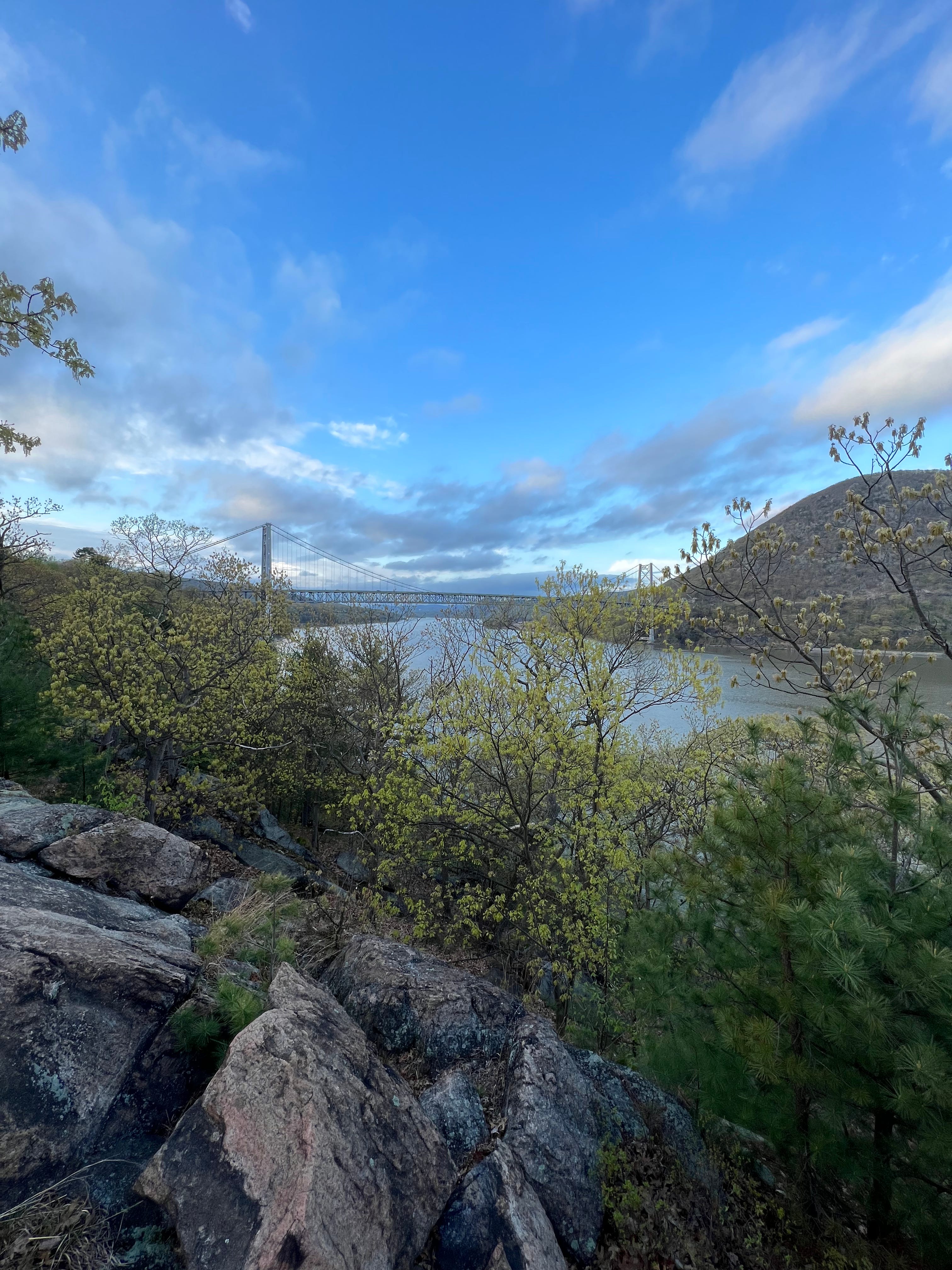
Standing 153 feet above the Hudson River, I couldn’t stop smiling — and laughing — as I crossed the Bear Mountain Bridge. The sun shimmered along the dark water of the giant river stretching out below me. I was only halfway across but already fully exposed.
I had arrived at Bear Mountain the day prior, having started the morning in Virginia and then proceeding around Washington, D.C. and its snarling traffic, across Maryland and then Delaware, up through New Jersey and finally along the Hudson’s shores in New York.
The trip was reminiscent of one I’d made, quite by accident, the summer before. On that occasion, I’d planned to fly into New York City and then take the bus down to Avalon, New Jersey, where I’d meet Allison and her family at the beach.
Instead, I’d ended up at Dulles Airport in Virginia, 26 miles west of Washington, D.C. Just as we’d been about to land at JFK, someone at Delta Airlines, or, perhaps, someone on the ground, had decided it was too foggy to make the approach. So, we diverted 260 miles south and west of our intended destination.
What followed was a remarkable, day-long Lewis and Clarkesque adventure (at least that’s how I styled it in my notes at the time) across Virginia, Washington, D.C., Maryland, Delaware, Pennsylvania and, finally, New Jersey — featuring three buses, two trains (one of which was Amtrak’s flagship Acela which can zip up to 150 mph), and one ill-fated scooter ride past the Capitol Building in D.C.
On this occasion, as I drove along the Woodrow Wilson Bridge, I looked out at the Potomac and was sorry there was so much exploring I wanted to do but couldn’t — even against the backdrop of my great exploration, my great saunter up the East Coast.
Bladensburg
Hyattsville
Patuxent River
While I was sorry to see Alexandria go, I was not sorry to see the roadside motels, which I’d slept in the past three nights, left behind. I couldn’t leave that last one — which, admittedly, did have a large and impressive mural of George Washington painted across an exterior wall — soon enough. The funk had hit me immediately the night before. As if the existential despondence of the place wasn’t enough, I’d turn a corner into the bathroom or walk into the main room and be hit with an invisible furnace blast of marijuana smell — deep, intense, offensive. If I were to write a review for the motel, which I didn’t, I’d advise razing it to the ground because it was beyond repair.
I realized I’d made it to Baltimore only because, as I sped along I-95, the Inner Harbor stretched out on one side and on the other there was a giant smokestack with the city’s name — in giant block letters — greeting me.
I fumed about the inability to pay tolls via cash — having no clue if my rental SUV had a transponder or if I was going to get slammed with exorbitant charges at some indefinite time in the future — and ended up detouring off the main road in an ultimately futile effort to circumvent them. Suddenly, I found myself driving through the cool, foggy Maryland countryside. Eventually, I found another bridge, which, naturally, required tolls of its own to carry me across the Susquehanna River, the very river I had trained across the summer prior in the comfort of a window seat on the Acela.
Crossing from Maryland into Delaware, I trailed a sedan with dual “Police Lives Matter” bumper stickers as I passed through the toll booth. I made an impromptu stop at the welcome center, which was officially known as the Joe Biden Welcome Center, in honor of the president who served the state in the senate from 1973 to 2009, an absurdly long run. Biden’s name was everywhere — written in so many places on the outside and inside of the building that I lost track.
Churchman’s Crossing
“Speeding you are, ticketed you’ll be,” warned one of those black freeway signs with orange, light-up lettering.
I rumbled over the Delaware Memorial Bridge, which is really two bridges right next to each other (one running east, the other west), soaring over the enormous Delaware River. I’d first spied the bridge — more specifically the towers, which stretch 440 feet above the water — upon approach, miles before I actually crossed it. I had to confirm it on the map, but I’d just left Biden’s state, the Delaware Memorial Bridge dropping me into New Jersey.
Oldmans Township — a name I just had to look up.
The answer was somewhat disappointing. It’s simply a corruption of Alderman’s, as in the governmental term, as I learned from The Origin of New Jersey Place Names, which I was thrilled to learn existed. The mimeograph was put together by out-of-work writers during the Great Depression as part of the Federal Writers’ Program of the Work Project Administrations.
The highs and lows of New Jersey.
I stopped at Weber’s Drive-in in Pennsauken — a charming little hot dog stand from a time past. The staff meets you at your car and then calls out your order, “Frank and fry,” in my case, as they walk back to the orange concrete shack, the words ROOT BEER plastered in black block letters. The drive-in experience was all foreign to me. Flip your lights on for service. Pull down your window ever so much so they can clip a tray of food to it.

Shortly thereafter, I tried to pump my own gas. A mortifying mistake.
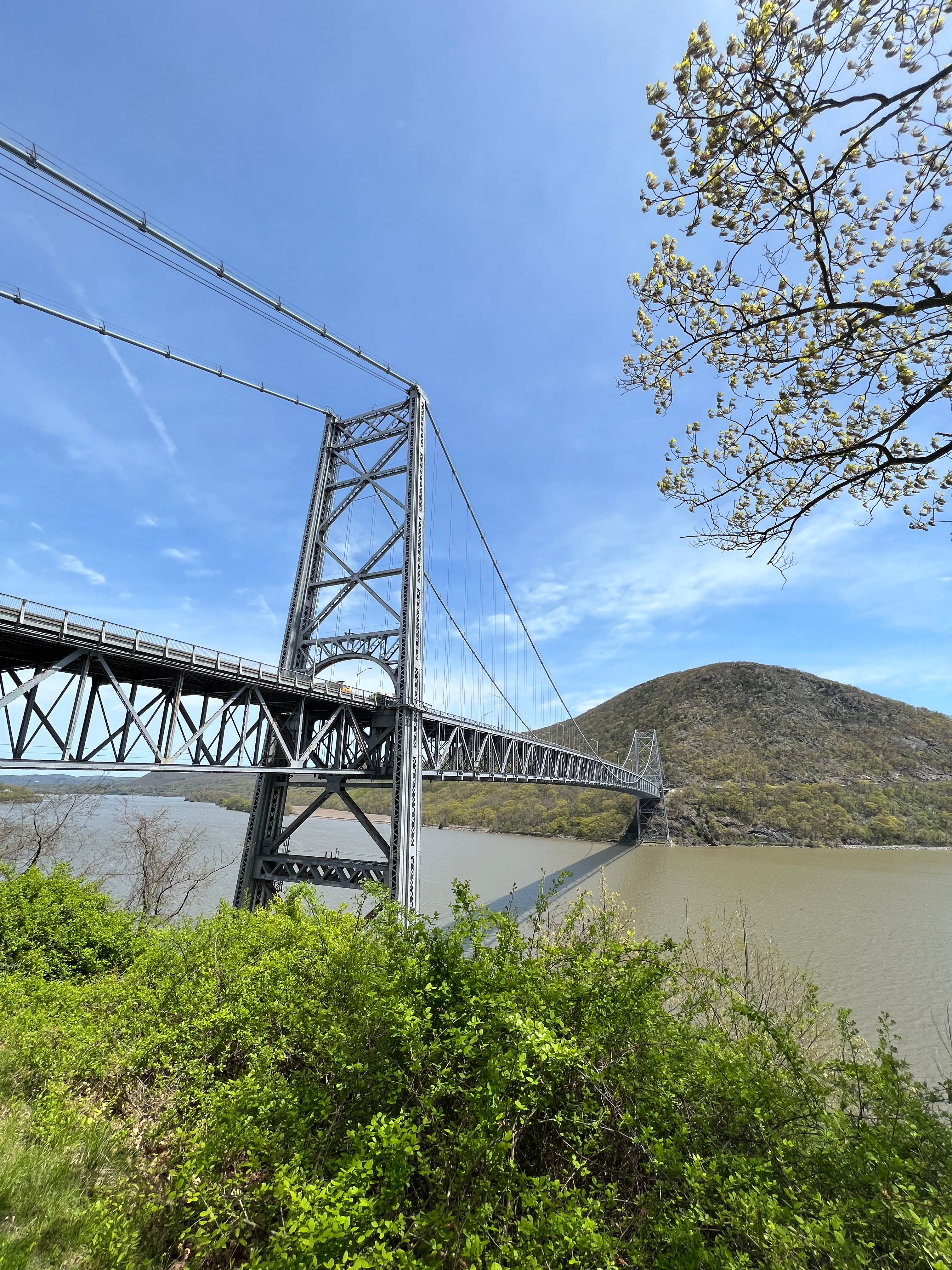
It immediately started sprinkling when I made it to New York. I finally got a glimpse of the Hudson while winding along 9W, the scenic route, which tracks the river. It was glassy, reflecting a power plant on the eastern shore across its surface. I could see the Bear Mountain Bridge through the trees.
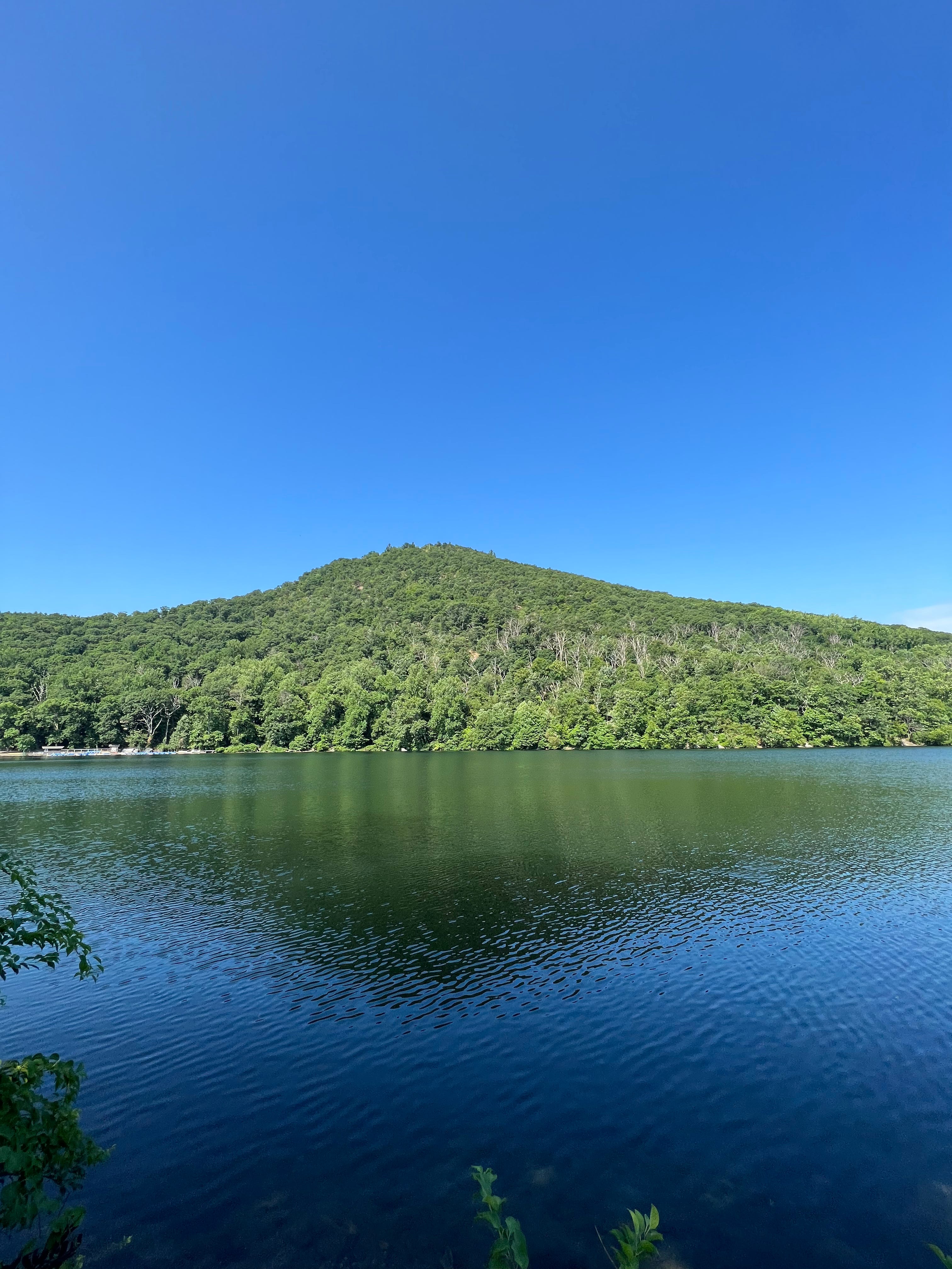
I arrived at Bear Mountain in time to do some quick evening exploring. I was standing along Hessian Lake, which was impossibly calm and scenic and which had boats for rent on the opposite side, just below Bear Mountain itself. I was, at once at the site of a long-ago Revolutionary War battle and right on top of the Appalachian Trail. A sign told all about the fighting that had happened back in 1777, but neglected to mention an important fact — how the lake got its name. As I’d learned in Cy Adler’s Walking The Hudson, the name comes from the roughly 200 Hessians, German mercenaries employed by the British, who were killed in the fighting and subsequently dumped in the lake. These days, fishing and boating are allowed, but you can’t swim, which is, perhaps, for the best.
Even though time was short, I couldn’t help but wander toward a stone bridge and then through a tunnel that led under the road, 9W, that I’d just been driving along.
My curiosity was rewarded.
I found a stone building that turned out to be a pool house of sorts, opening up to a giant, Olympic-sized pool that was gated off and empty — either abandoned or, at the very least, out of season. I kept walking, wanting to get down to the Hudson docks, or even just catch a glimpse of the Bear Mountain Bridge and Anthony’s Nose, the more than 900-foot peak on the eastern bank. And I did.
Trampling through the brush and along the iconic Hudson Valley stone cliffs, what unfolded before me was an amazing sight. The bridge spanned high above the river. I could see miles north up into the Hudson Highlands, out to Anthony’s Nose directly across from me and back down south where the river flowed toward New York City.
I had made it to Bear Mountain. It was a trek. It was a delight. The next day, blisters willing, I would walk across the bridge.
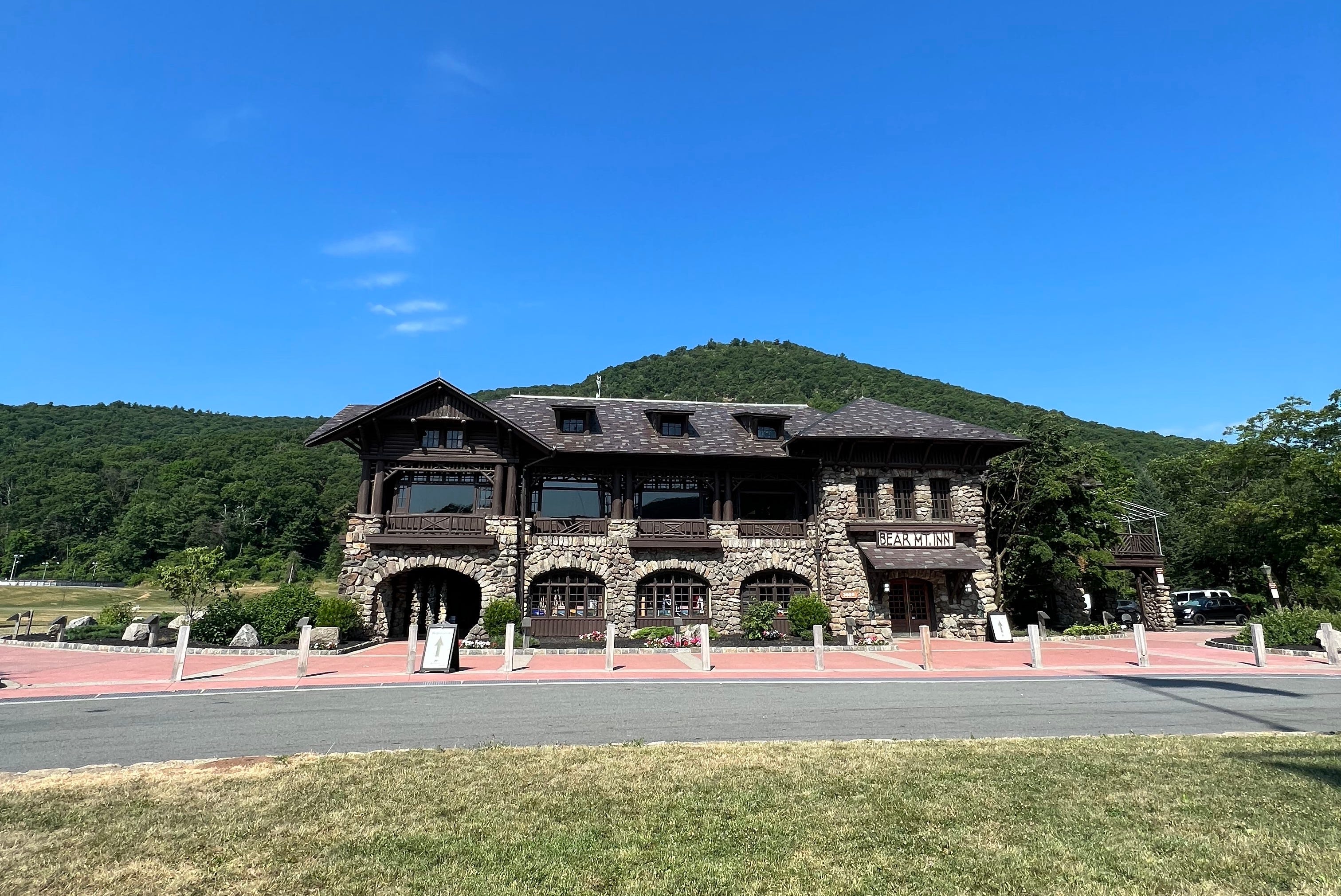
That night, as I pulled up to the Overlook Lodge, which, aptly, overlooks Hessian Lake and the Hudson beyond, I realized that my car was the only one in the lot. It followed that I might be the only person at the hotel, as there was no staff on-site. The Overlook is one of three lodging options on the grounds of the eponymous state park. There are the Stone Cottages (the most basic), the middle-tier Overlook Lodge and the Bear Mountain Inn itself, the crown jewel of the place.
Built with a stone foundation and locally-sourced chestnut timber, according to the Bear Mountain website, the Inn has the look of a classic mountain lodge. Inside, the ceilings are tall and there are big logs everywhere interspersed with stone columns. On the second floor, I found two empty ballrooms — ready to welcome guests and events — and the locked Eisenhower Boardroom. Vestiges of a grandeur past. Upstairs there was also Restaurant 1915 — a largely empty yet stately dining room — and Blue Roof Bar where I dined. Somewhere, tucked away, were the 15 guest rooms.
My experience was certainly colored by the fact I’d arrived between the heights of the winter and summer seasons, but it was a shame to see such a beautiful and historic facility so underutilized.
Back in the 1930s, the Brooklyn Dodgers, New York Giants and New York Knicks used the Inn and its expansive grassy fields and facilities as their training headquarters. Presidents Franklin D. Roosevelt, Harry S. Truman and Dwight D. Eisenhower all visited.
In another reality, the Inn, designed in the style of the Adirondack Great Camps, wouldn’t even exist at all. Sing Sing, the maximum security prison, was originally slated to be built on the site before some of the area’s richest residents interceded in 1908. These patrons donated a million dollars — and large swaths of land — to the Palisades Interstate Park Commission to make Bear Mountain a state park instead. The Inn opened in 1915. Now, the prison is 30 minutes down the road on the opposite bank.
Back in my room at the Overlook Lodge, I considered calling down to the Inn to see if I could get upgraded to the flagship property. It felt strange, a little spooky, to be the only person in such a big hotel. Instead, having traveled 1,000 miles by car and another 20 or so by foot in the past four days, I feel fast asleep.
Originally, I’d planned to go just halfway across, but I couldn’t fight the explorer’s urge. There was a short concrete wall to one side and a metal railing on the other, overlooking the water far below. What a place to be. As the cars and especially the trucks rushed past, the bridge had some give, bouncing up and down a bit, a small but perceptible amount.
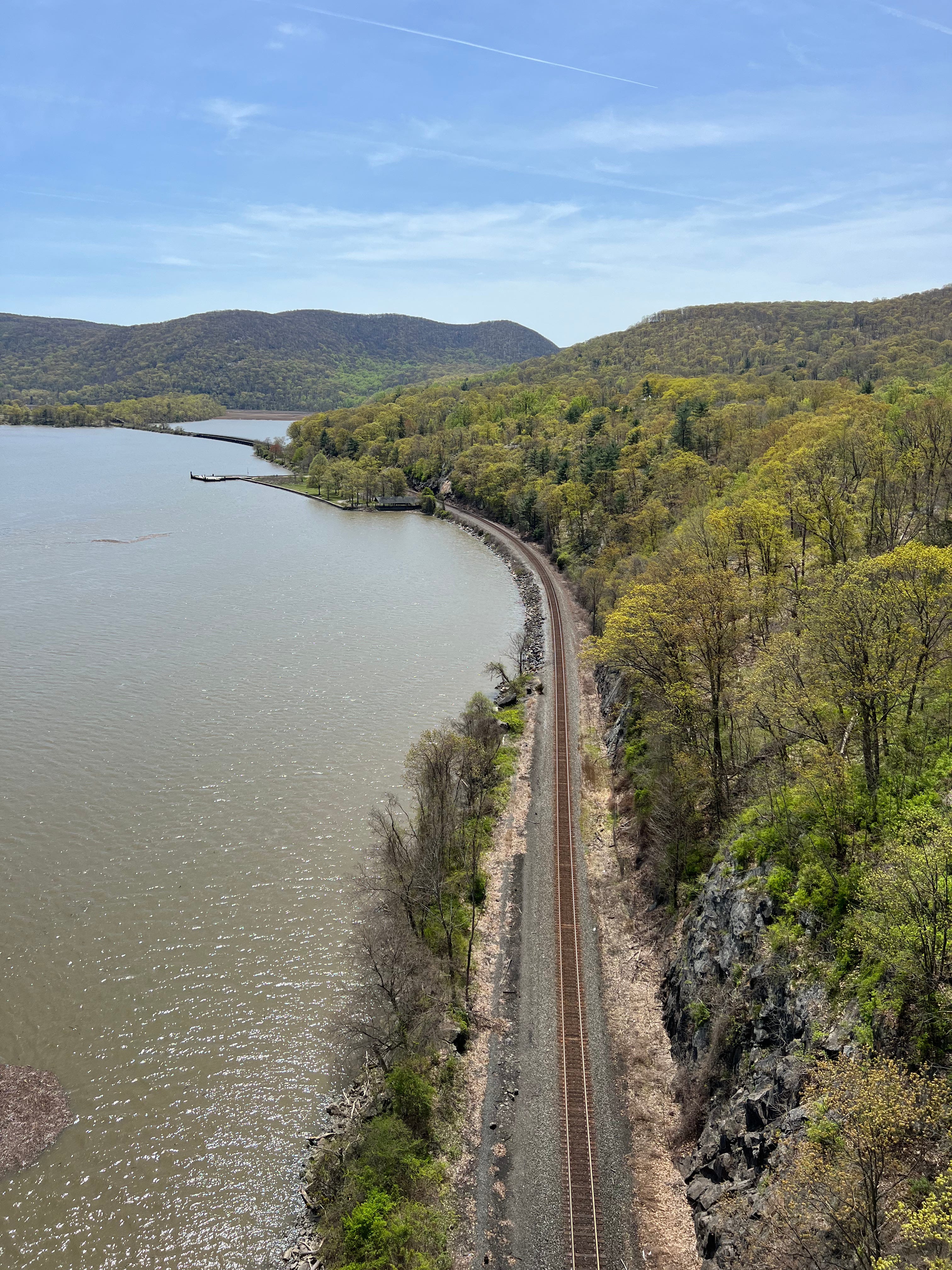
Looking out to the right, I could see way down the river, Iona Island — connected to the main bank only by an elevated railroad bridge that I wanted to scramble across — jutted into its path. Bear Mountain was now behind me. To my left was Anthony’s Nose. Surprisingly, there is no definitive explanation for the origin of that memorable name. An Amtrak train rolled past on the eastern bank at the nose’s base. The track on the western shore lay quiet. Up north, I could see houses perched, peeking out from among the rolling green hills of the Hudson Highlands.
As I stood at the midpoint, beaming, I further resolved my long-term plan to voyage up the length of the river on a boat of as-of-yet undetermined size from New York City to its northern-most point. Now, the wind was really starting to pick up. I had to hold onto my palmetto and moon hat to make sure it, or I, didn’t blow off into the Hudson more than 150 feet below.
I had an enormous grin on my face. I couldn’t stop smiling. I couldn’t stop taking photos and videos. In one, I spun all around, revealing all the scenery, and at the end, my mouth gapes open in utter delight. Just as I’d been thinking about the western track staying quiet, a freight train arrived, stretching on for miles. I had nearly crossed the bridge myself by the time the caboose had finally arrived.

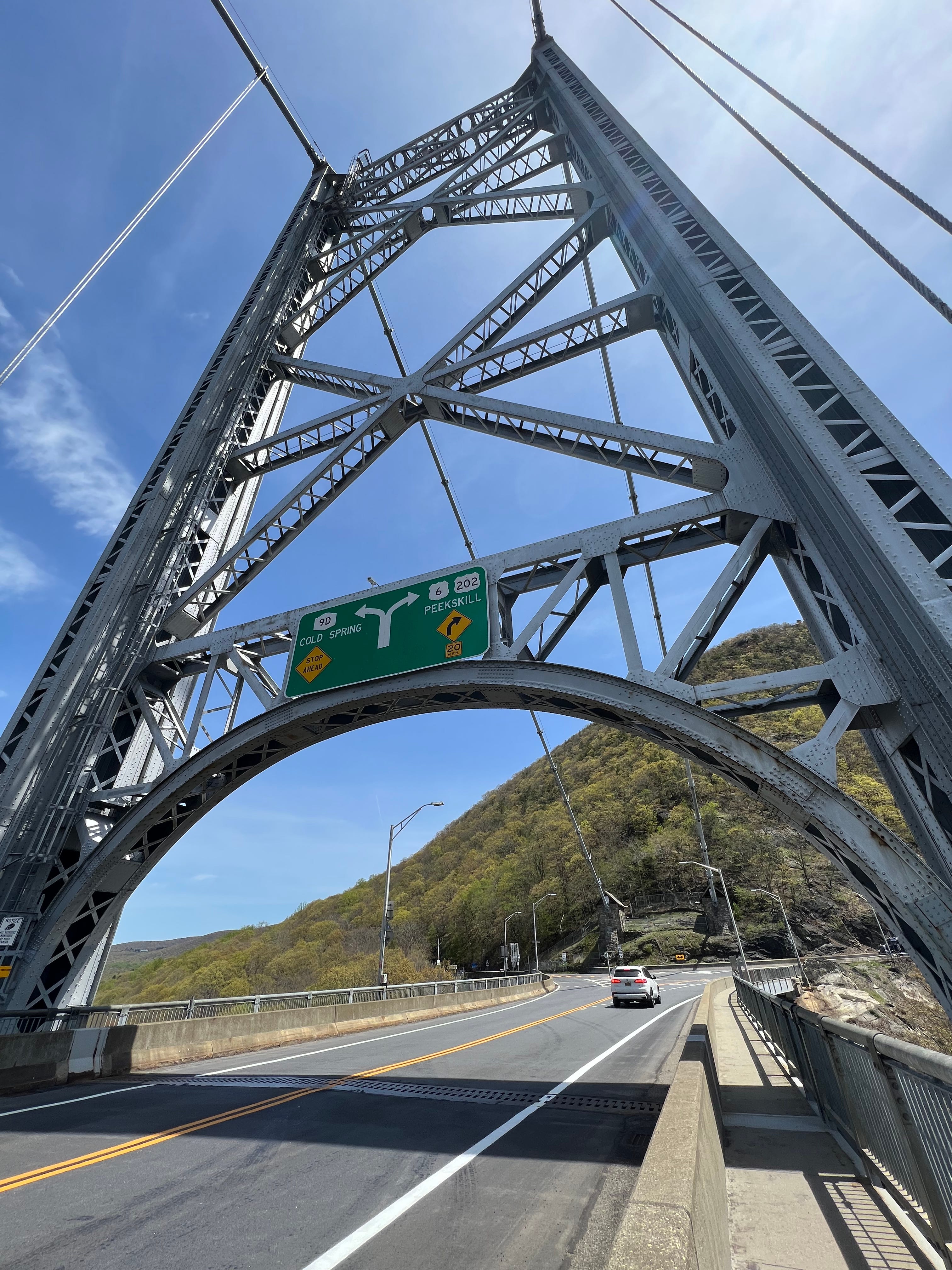
Where the bridge meets the road on the eastern side there was a sign cautioning about a peregrine falcon nesting site.
“Falcons may be aggressive during nesting season from early May to the end of July.”
Oh, I’m fine, I thought before realizing that May had just begun.
Interestingly, it wasn’t until I’d walked that final little stretch of the 2,257-foot bridge when it hit me that it was nothing more than a road suspended over pure air, and I recalled that I am intermittently afraid of heights. For that reason, and because the wind was really swirling, I hustled back. On the western edge, the side I’d started out on, the New York State Bridge Authority had two beautiful stone buildings, which served as headquarters and facilities. Affixed to the wall is a plaque with some of the stats I’ve already mentioned — like the height over the water and the length of the bridge — and one I haven’t, that the towers are 355 feet tall.
There’s also another plaque nearby. It’s a blue sign with a yellow-golden border and the same colored text, which commemorates the Appalachian Trail I was currently walking along. It was all coming together for me. Here I was at Bear Mountain, the terminus of Cy Adler’s Walking The Hudson while traveling along the Appalachian Trail, which guides Bill Bryson’s A Walk in the Woods and features so prominently in Christopher S. Wren’s Walking to Vermont. In a couple of days, I’d, quite literally, be completing Adler’s other book, Walking Manhattan’s Rim: The Great Saunter.
I didn’t realize it at the time, but the path I’d just walked along was the very first stretch of the Appalachian Trail ever built. In 1923, a group of volunteers from the New York-New Jersey Trail Conference completed the track which climbs up and over Bear Mountain, along the edge of Hessian Lake and then across the Bear Mountain Bridge. I only learned this by chance when I happened to read a sign — which helpfully notes that it’s only 1,403 miles to Georgia, the trail’s southern-origin point — on the shores of the lake. I had just completed the Bear Mountain Loop on my second visit in mid-July, some two-and-a-half months later. My hike was just over six miles, including 1,247 feet of elevation gain, some of which was earned by scrambling up and over Mammoth rock outcroppings, as a trail sign termed them. On the way down, I bounded out onto one of those giant rocks, taking in the effectively infinite green forests that rolled out before me, the wind rattling the trees, the river standing calmly off in the distance.
Before flying down the Palisades Interstate Parkway and dropping my car at Newark Airport, I did have a bit more exploring to do.
I — accidentally — trespassed into the Trailside Museums and Zoo located right next to the bridge. I wandered in through what turned out to be a maintenance gate and was only asked to leave after a worker noticed me taking photos of the towering bridge. I failed to trespass on the railroad bridge that I had spied earlier, leading from the western shore of the Hudson out to Iona Island.
After seeing the NO TRESPASSING sign, I took a few steps out on the dilapidated old wooden planks of the bridge that ran along the railroad tracks. Ultimately, I thought better of it. In the moment, and even more so later, I lamented not going for it and perhaps forcing a confrontation with the New York State Park Rangers or possibly even the Palisades Interstate Parkway Police Department. Imagine the story if I had been remanded to some jail in Bear Mountain State Park. There is also the consideration that if I had proceeded on, I could have found myself in the situation where I would have had to leap off the bridge and into the water to avoid getting bowled over by a train.

I finally did drive to Iona Island, now a bird sanctuary. It’s officially known as the Iona Island-Doodletown Bird Conservation Area. According to a sign, Doodletown may have gotten its name from British troops passing through in 1777, who mocked the residents for the “Yankee Doodle” song. Subsequent research indicated that the name actually comes from the Dutch term for “dead valley.” I prefer the sign’s explanation. These days, the place is a ghost town. The Palisades Park Commission purchased it in the 1960s, incorporating the land into Bear Mountain State Park. Remnants of the town, such as foundations, stone walls and old roads, can still be seen in the forest.
Just as I was thinking how I could have scampered over the wooden bridge, I saw a truck race along the tracks — retrofitted with what amounted to metallic shoes or skates, allowing it to fly along the rails.
Before making the thrilling drive up Bear Mountain, a sloping, windy road, which seemingly encircled the entire slope, I tried to tune out a weather report that said something about a 90% chance of rain on Saturday, and, I think, 40 mph winds with highs of 52. Shorewalkers had also sent out an email about planning for inclement weather.
On the summit, as I headed toward the Perkins Memorial Tower, I glimpsed the hazy blue silhouette of the Manhattan skyline, some 50 miles south. I followed the scenic route down the mountain and was rewarded with a stunning view of the entire valley — Bear Mountain Inn with all its grounds, Hessian Lake, the Hudson River and the bridge spanning it, Anthony’s Nose, Iona Island and that damn railroad bridge, and beyond the rolling hills, the tallest buildings of Manhattan, nothing more than hazy blue lines sneaking over the horizon.

About an hour later, standing outside an Exxon station/7-Eleven in Newark, New Jersey, across the street from the Hertz lot where I’d just dropped off my rental, I was taking inventory of all the ridiculous items I was holdings as I stood on the grassy berm, waiting for a ride. A red Wawa bag with a rolled-up map, which I’d purchased at the Fountain of Youth a thousand miles ago, sticking out of the top. My backpack strapped to my back, another map tucked away safely inside. And my giant duffle bag, packed full with my long-since forgotten suit, resting at my feet. And, just as I thought that, I looked down and suddenly realized it was nowhere to be seen.
Right at that moment, just as Allison was making the turn, I realized what had happened. After a quick explanation, I darted across the street and went running across the Hertz lot. There it was — right where I’d left it — sitting on a bench outside the office. I was never actually concerned that my bag had vanished, or that I’d left it somewhere in the Hudson Highlands. I actually felt confident as I sprinted back. But still, what a near disaster.