


The Greatest Saunter
Part IX: Fraunces Tavern to Inwood Hill Park

EDITOR’S NOTE: This is an ongoing series about setting out to hike 32 miles around the island of Manhattan in a rainstorm and the thousand-mile road that led there.
Part II: Men’s Wearhouse and Mount Everest
Part III: The Fountain of Youth
Part V: The Giant Sombrero in The Sky
“Distance changes utterly when you take the world on foot. A mile becomes a long way, two miles literally considerable, ten miles whopping, fifty miles at the very limits of conception. The world, you realize, is enormous in a way that only you and a small community of fellow hikers know. Planetary scale is your little secret.”
—Bill Bryson
What a delightfully stupid day, I thought to myself as I arrived at Fraunces Tavern at 6:54 a.m. on a cold, wet and rainy Saturday morning in May that, by any objective measure, should have been miserable.
A crowd had already formed. I loved the energy of these fellow saunterers who were ready to circumvent the island by foot or die trying. It was time to walk 32 miles around Manhattan.
I’d slept maybe four hours the night before. I was in bed by 11, but I couldn’t get to sleep until sometime after 12:30. It was loudish in the hotel, and, more so in the city — which is hardly a surprise. At some point, the sound of bottles getting dumped on each other rattled through the canyons of the Financial District, echoing loudly. I first saw the clock at 4:36 and tossed and turned, futilely, after that.
After I’d checked in, collected my black Great Saunter cap, and affixed my bib — No. 1339 — to the top of my backpack, but before setting out, I needed an iced coffee. So, I went about 100 feet in the wrong direction — with what lay ahead of me, this was not the day to go the wrong direction, no matter how short. At 787 Coffee Co. I fueled up and even got a peanut butter and jelly sandwich— a happy accident as I’d just been thinking about how much I’d wanted one.
When I’d re-emerged from breakfast, the rain had started to fall. The aforementioned Fraunces Tavern — the oldest building (and restaurant) in Manhattan — dates back to 1719. It’s soaked in history. A British cannonball crashed through its roof in 1775. In 1783, George Washington, still a general, “bade an emotional farewell to his officers at a banquet held in the Long Room, located on the second floor,” as a plaque, fastened to the brick exterior of the building, proudly proclaims. I was thrilled when I found out this would be the starting and ending point for the Great Saunter.
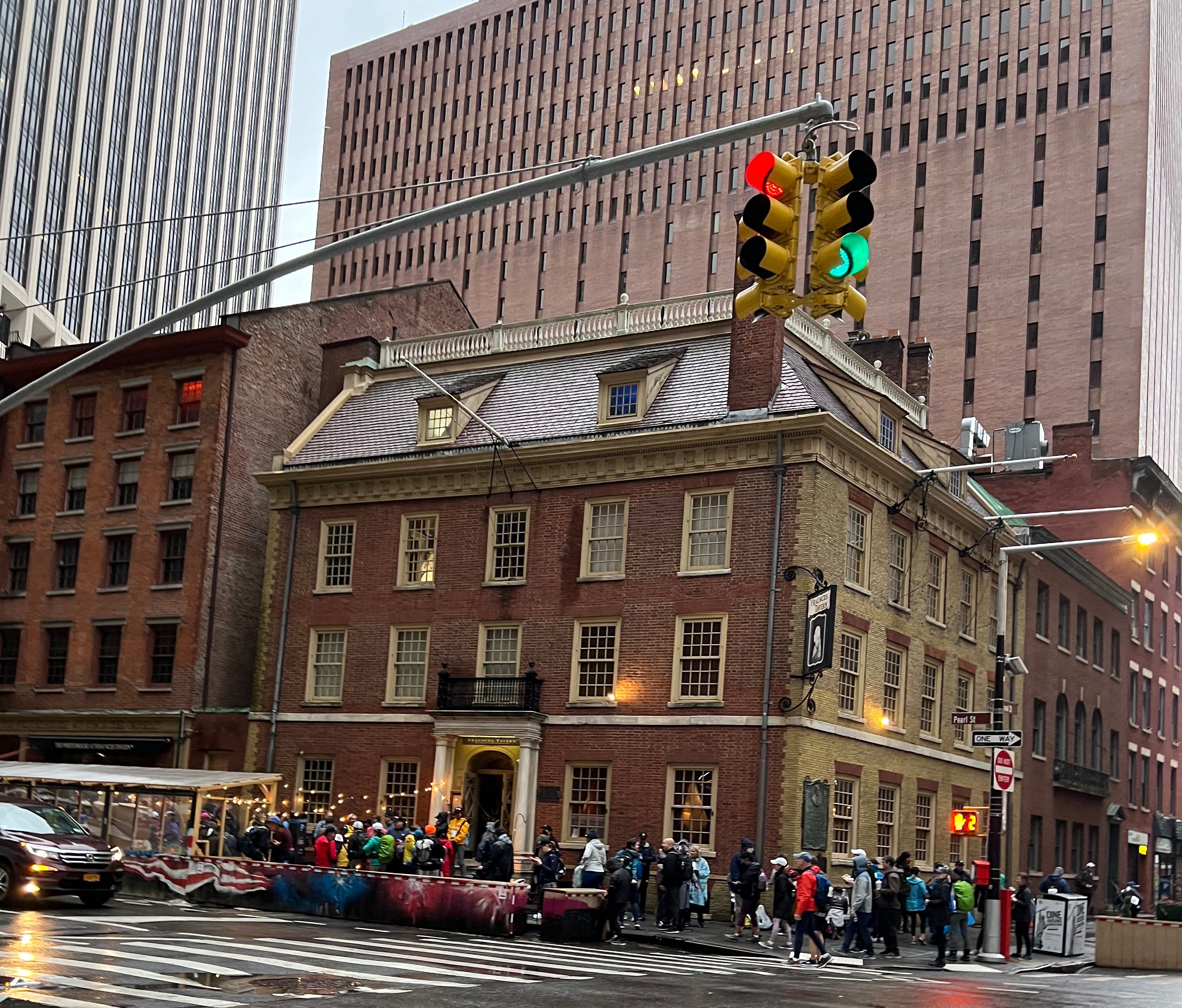
The summer before, I’d stumbled into the place, drawn in by its brick facade and historic charm, characteristic of many old buildings in that corridor of the Financial District. I ate a burger and had some beers after spending the day running all over the island and riding NYC Ferry along the East River.
By the time I made it to Castle Clinton in Battery Park City, the first of 20 parks along the route, my shoes had already long since soaked through. Off to my right, I saw the Freedom Tower, its shiny point shrouded in fog. I detoured to the shore to see a beautiful gray view of the horizon. I was looking out at the spot where Henry Hudson had sailed into the harbor and up the river (eventually making it as far as Albany). Hudson had much better luck than I on that distant day in 1609. The weather was “very faire and hot,” according to the diary of his first mate, as excerpted in Eric W. Sanderson’s Mannahatta: A Natural History of New York City. The giant book includes stunning recreations of what the overwhelmingly green island may have looked like before Hudson and the rest of the Europeans arrived.
On this Saturday morning, the Hudson was gray and vast. If you had the misfortune of falling in — perhaps off a ferry — it looked like it would suck you under in a moment. Just past Rockefeller Park, a gust of wind picked up. Another unwelcome element to contend with. And then it really picked up, rattling ponchos.
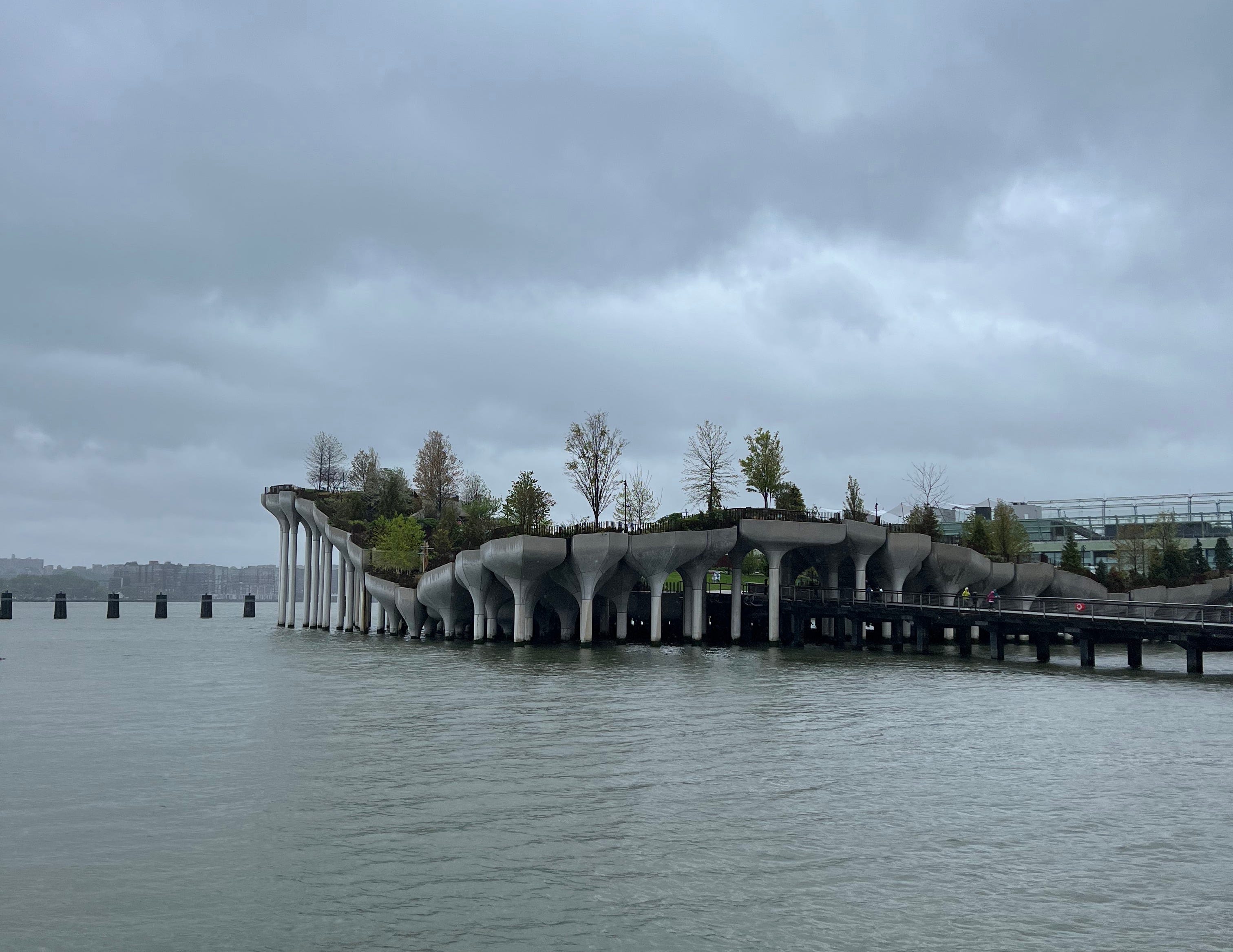
It was 8:10 a.m. — I was soaked, sweating, my glasses fogged — when I made it to Little Island. Some bold fools were detouring onto it. I settled for a few pictures. Little Island is truly a one-of-a-kind place. Connected to the Hudson River Park by a couple of walkways, the island consists primarily of 132 concrete tulips with lawns, paths and trees at its center. The 35th Great Saunter was the first time participants could view the unique island as it was only opened in May of 2021 and that year’s event was held virtually, owing to the pandemic.
Walking past Chelsea Piers, the official Great Saunter Google Map showed me to be in what I termed, unofficially, a bathroom desert. I had so far been stymied in my first two attempts to find a bathroom that was either unlocked or unoccupied, and I didn’t see another one on the map until Riverbank State Park — some distant park well over 100 blocks north — which may as well have been Poughkeepsie. I will never forgive people for being such idiots, such animals, I thought, that we can’t be trusted with the responsibility of public bathrooms in urban centers.
And so it was that I found myself in between 28th and 29th St. — maybe one-tenth of the way through the Great Saunter — when my umbrella flipped inside out as the rain hammered down and the wind ripped.
I’m not gonna make it.
God bless NYC Ferry. Right when I needed a brief, warm, non-rainy reprieve most, I realized I was just shy of Pier 79, which housed the Midtown West terminal. The very terminal I’d set off from the first time I’d ridden the St. George route, which had only opened some 10 months earlier. Incidentally, that had also been an unseasonably overcast, if not rainy day, as well.
Inside the main entryway, I was surrounded by fellow Saunterers, who, like me, just really needed to dry off. I sat there, bare feet out, before making what I assumed would be the first of several sock changes. Back outside, the rain relented a bit. In no time I’d hit the five-mile mark where Shorewalkers volunteers offered granola bars and smiles. What great people — a theme I’ve noticed with everyone involved in the organization — to be out there on a day like this, I marveled.
Moving past the Intrepid, the massive aircraft carrier that anchors the maritime museum at Pier 86, my left foot — the same one I’d injured on the Dipsea Trail so many months ago — began to hurt. But the lack of rain had given me new life. The pier numbers kept getting bigger and I started blitzing past people. I even blitzed past a porta-potty, which may have been an error.
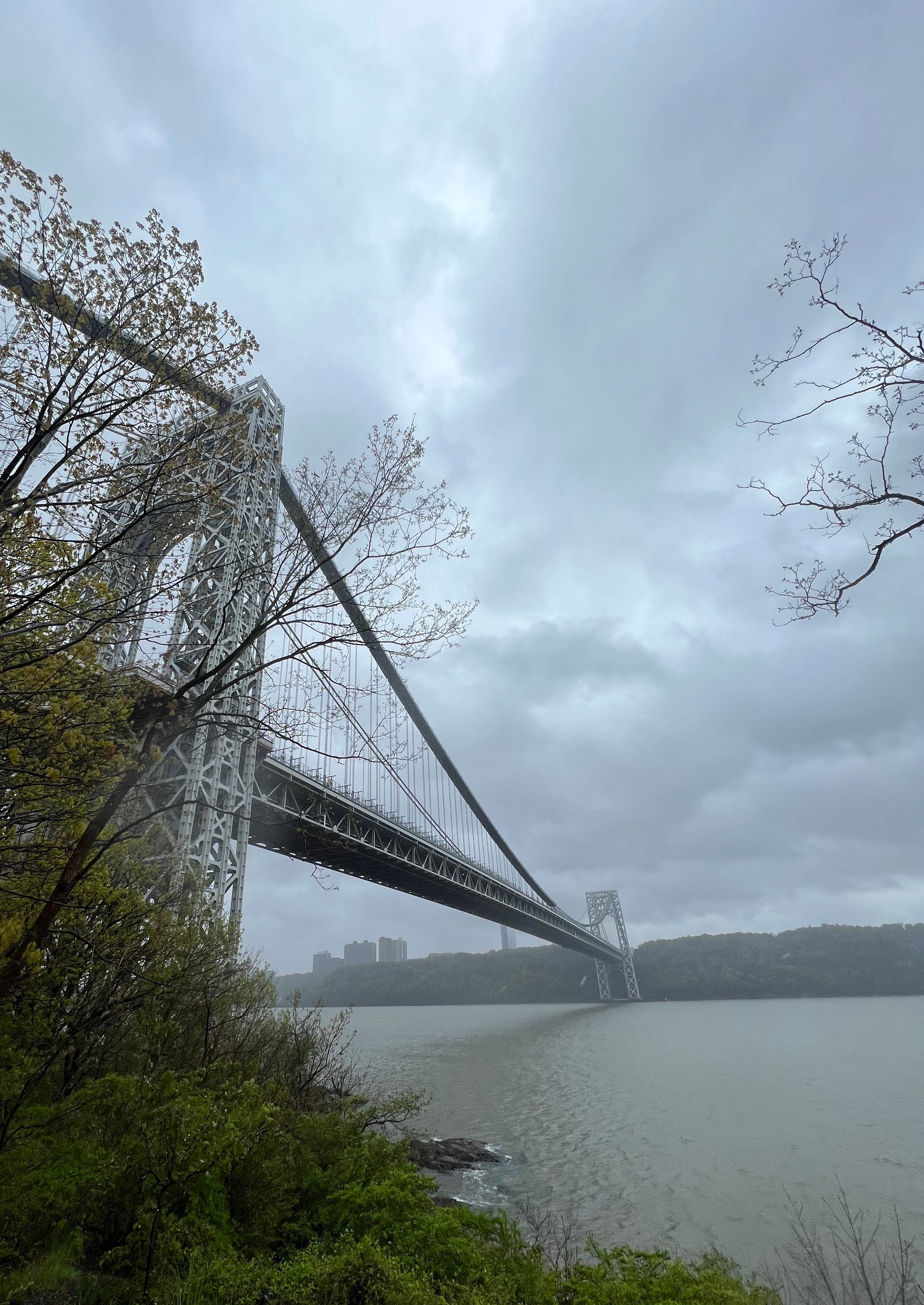
The wind picked up as I walked away from the city and into Riverside Park South. The Hudson was a sea of a million tiny waves. It looked downright menacing. The George Washington Bridge was only a faint pair of towers impossibly far off in the distance. Abandoned pilings dotted the water just off the shore, rendering that slice of the river unnavigable, a death knell for any boat.

By 10:02 a.m. the rain had picked up again because of course it had.
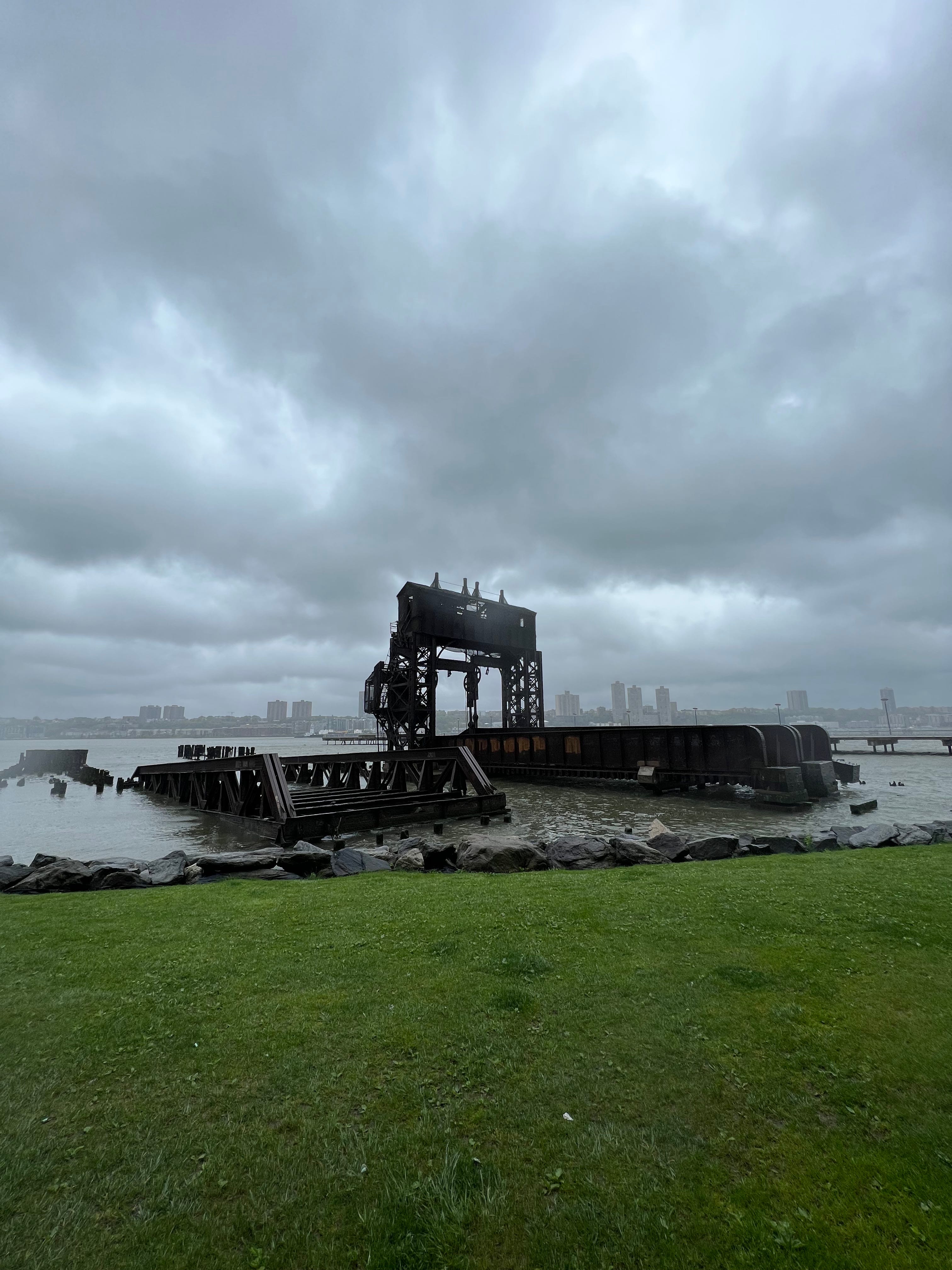
From a distance, the 69th St. Transfer Bridge appears black, but it’s actually a rusted structure jutting out from the shallows of the river. In another life, this was a transfer terminal that the New York Central Railroad used to move freight from the trains to river barges or float cars, which sailed across the river to Weehawken Yards in New Jersey. The dilapidated structure certainly catches the passerby’s eye — and curiosity. Fortunately for me, there was a bathroom nearby.

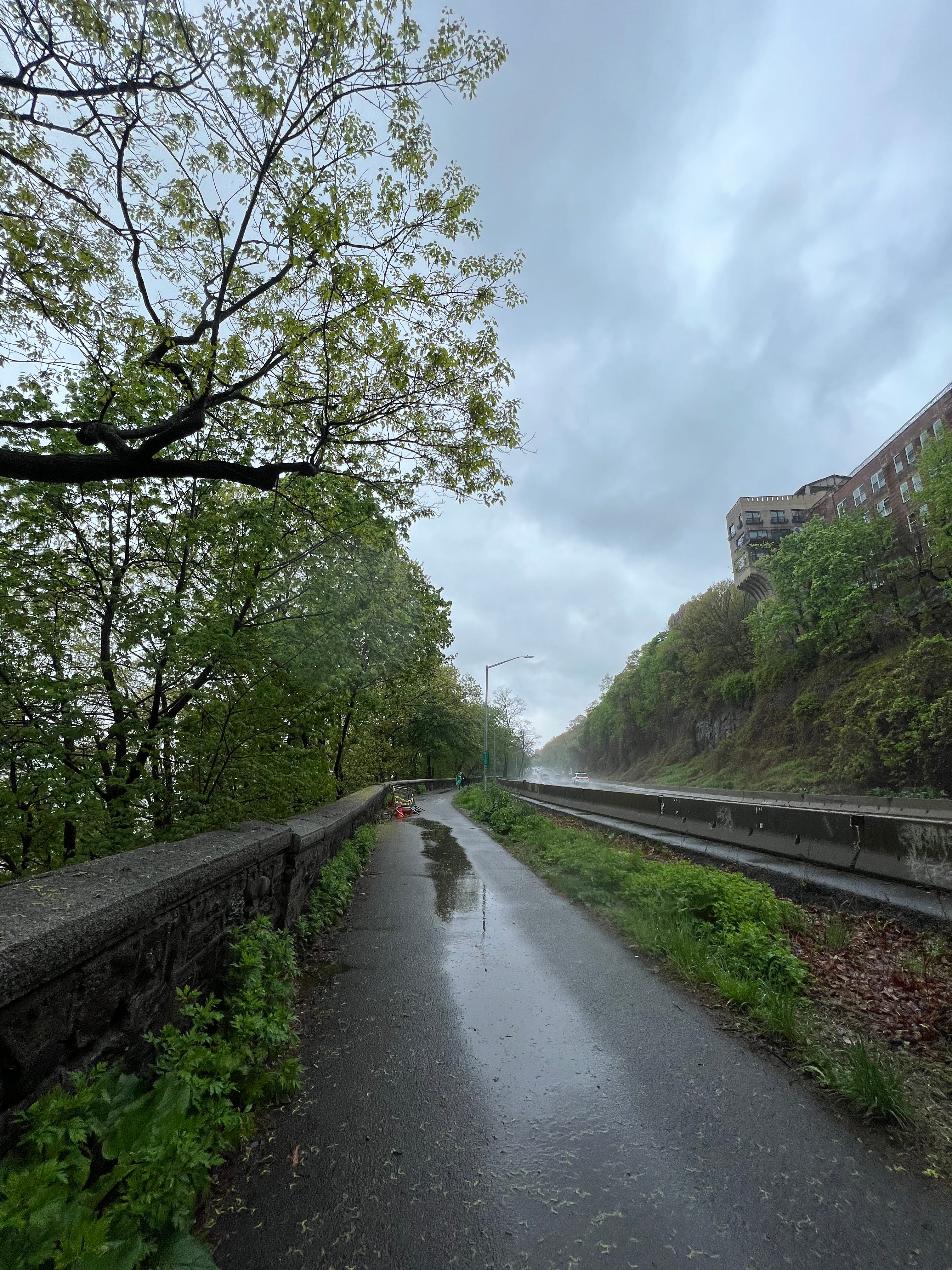
I was flying along so fast that I almost stepped on a dead, wet rat. Unfortunate little rodent. The George Washington Bridge was still shrouded in fog, but now I could see the full span. The rain was lashing me and the wind was ripping, and now the path took us along a literal highway. Cars were racing along the Henry Hudson Parkway at 60 mph, emitting trails of mist.
“Ah fuck,” I shouted, surprised, after I’d been splashed by some car that ripped through a puddle.
I just missed getting splashed by another car racing through an even bigger pool. The water sprayed, almost cinematically, in a giant arch above my head but I was far enough to the left side of the path to avoid the splash zone. Out on the Hudson, a tug pushed another boat, inching up the river.
Welcome to Harlem, I thought to myself.
I was at 125th St., Columbia was just blocks to my right, when a friendly volunteer informed me that there wasn’t a bathroom until 157th.
“Ah shit.”
My phone was getting so wet whenever I took it out to take a photo or jot down some notes that it was hard to type. But when I put it in my pocket, ostensibly to dry it, my pocket, too, was entirely soaked.
An unmarked police car, with red and blue lights flashing in its window and white lights near its bumper, had pulled a car over under the highway. I, too, paused under the Henry Hudson Parkway to dry my phone. Strava told me I’d gone 10.05 miles — damn near one-third of the way.
Wandering under a maze of latticework, I walked below the parkway which was perched overhead, held up by charmingly rusted, green metallic legs. I was surprised to find a soccer field — the home of F.C. Harlem — tucked in between the road and Riverside Park. The club has provided more than 10,000 kids with free soccer and mentorship programs since it was founded in 1991, according to its LinkedIn profile.
Just before arriving at the George Washington Bridge and the Little Red Lighthouse, some four hours and 13 miles into my adventure, I stepped in dirt for the first time all day, squishing in the mud. It was fitting as the path I’d walked — from Fraunces Tavern up the western edge of New York City — “rests almost entirely on man-made land,” as Cy Adler notes just a couple of pages into his Walking Manhattan’s Rim.
The Little Red Lighthouse, standing at the foot of the George Washington Bridge, was one of the sights I’d most looked forward to seeing in the run-up to the event. Now that I approached it amid the rain, I only had time to glimpse it from a distance. I couldn’t justify veering off the path to explore. Before the George Washington Bridge opened in 1931, the Little Red Lighthouse guarded Jeffrey’s Hook, the swiftest section of the river along the shores of Manhattan, according to Adler. The lighthouse actually began its life in 1880 at Sandy Hook, New Jersey, at the southern entrance of Lower New York Bay. In 1917, the 40-foot lighthouse was taken apart only to be rebuilt at its current location in 1921.
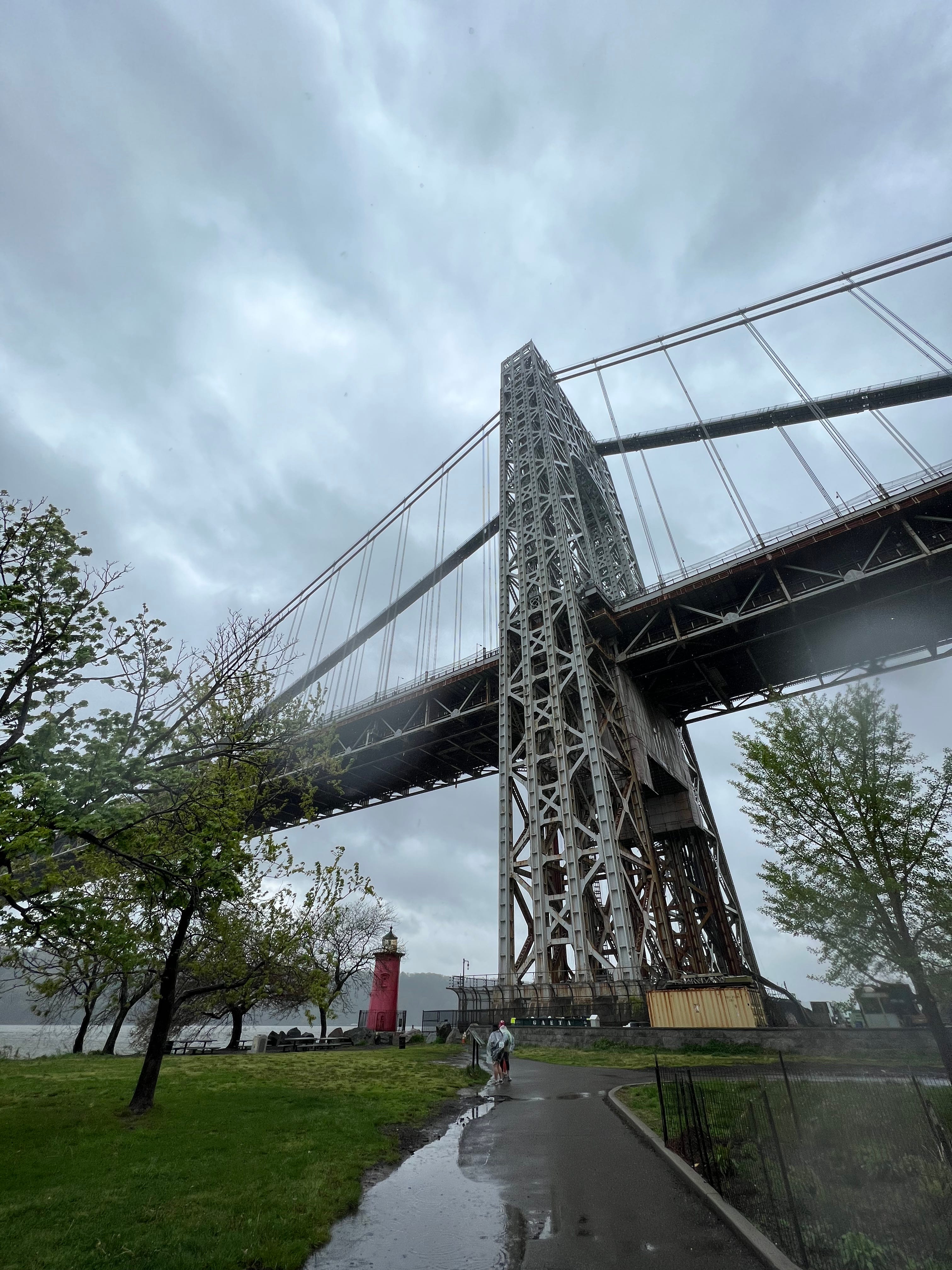
I found Gandalf standing under the George Washington Bridge. I’d originally seen this costumed saunterer — complete with beard and staff — first thing in the morning outside Fraunces Tavern. The bridge was impressively tall, towering 604 feet. Driving across is absurdly expensive. It’s $16, if you’re paying cash, on the way into the city. As the whitecaps rippled along the river, I scrambled down to a muddy perch to capture a shot of the idyllic Hudson and the bridge. I slipped on the way back up, tweaking a muscle.
Just beyond the George Washington Bridge, at a bend in the path, I met Allison who was planning to walk part of the route with me in spite of the disastrous weather. Tucked into her backpack was a variety of dry clothes, none more important than the bright yellow poncho that was about to save the day.
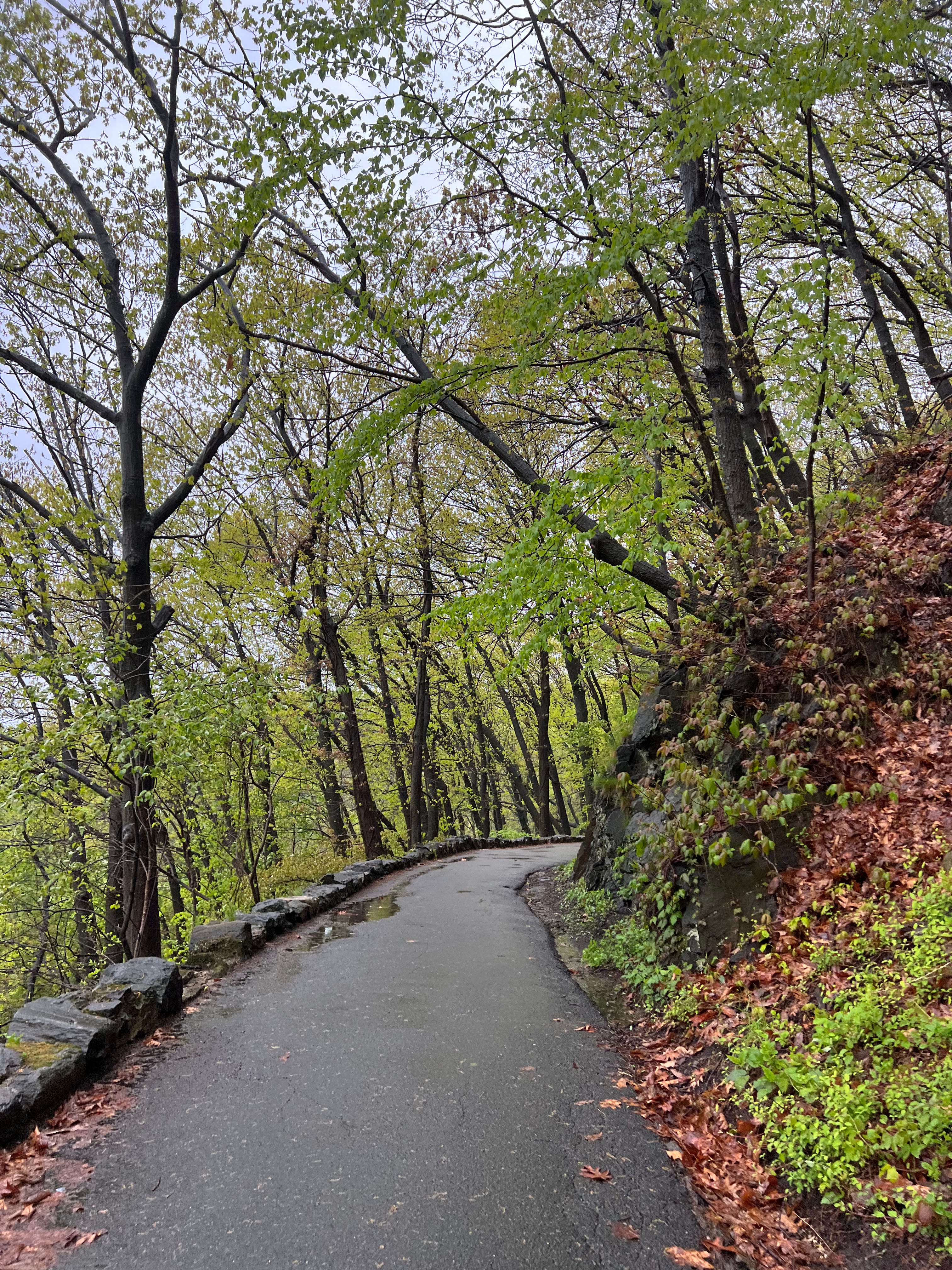
What a cool, unfamiliar part of the city we’d just ended up in. All the trees and rocks towering above us. This was a pretty good approximation of what Manhattan should have looked like. It reminded me of the Hudson Valley, of the landscape I’d just sped past a couple of days prior while racing down the Palisades Interstate Parkway. Atop some of the rock cliffs sat apartment buildings, the impressive Hudson Heights.
I had no idea what landmarks I was walking past. Off to the left, we followed some concrete steps that led up to a brick landing. It was a gazebo held up by giant white columns. Officially, this is Inspiration Point. The “neoclassical sitting area,” as the NYC Parks Department puts it, was opened in 1925 as a rest spot for walkers and drivers. Thanks to subsequent construction, it is now only accessible by foot or bike. The view looked beyond the tops of the bright green trees, out across the Hudson and to the Palisades on the opposite bank. We kept walking. Off to right, I saw big stone arches. I thought I was looking at a fort. I wasn’t. As I later learned, it was actually the remnants of a long-since burned-down estate.

As we reached the northern-most tip of Manhattan — where a tiny railroad bridge, the Spuyten Duyvil, crawls just over the water, stretching across the Harlem River to the Bronx — I saw the same tug boat I’d seen hours earlier, still pushing its way up the Hudson.
Inwood Hill Park, which I’d never been to, was even more impressive than I could have hoped. So, too, was the Henry Hudson Bridge, which I’d first spied a couple of days earlier from a distance when I dropped down from Bear Mountain to Newark. Walking through the woods of northern Manhattan, along a tree-lined path that snakes through the park, the Henry Hudson Bridge looked blue against the gray sky. The bridge reaches across to the Bronx, just like the Spuyten Duyvil Bridge. The middle span of the Spuyten Duyvil, which sits just feet above the water, swings open — like some giant floating gate — so that boats can cruise past.

It was pouring rain as we made our way through Inwood Hill Park, which boasts the last natural forest and salt marsh in Manhattan. A veritable deluge. In a small, circular clearing, centered around an unremarkable rock, a friendly volunteer advised us that we were at the halfway point.
“We are?!” I turned around and beamed.
It was not until exactly a month later, as I revisited my Inwood Hill Park notes while I flying home from Mexico City, that I realized the significance of that seeming unremarkable stone. Bolted to its stone face is a plaque that I had no time to stop and read and almost certainly didn’t see through the driving rain. It’s Shorakkopoch Rock, the supposed site where Peter Minuit “purchased Manhattan Island (from the Lenape) for trinkets and beads worth 60 guilders.” It seems like an ugly historical moment to commemorate in such a beautiful park.
On the day of the Great Saunter, I managed to jot down over 2,600 words of notes, despite the fact that in many instances it was nearly impossible to type because so much water was pooling on the screen of my phone. To my great surprise, I did not note the exact moment when it occurred to me, unequivocally, that I was going to complete this 32-mile loop. That realization arrived at some point during the 20-block window between when I changed my socks at the Midtown West ferry terminal and when I entered Riverside Park South, just beyond Pier 99. What I had failed to account for is that I might die on E 126th St.